 |
| NPS Image |
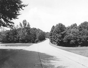
The Colonial Parkway is a twenty-three mile scenic roadway stretching from the York River at Yorktown to the James River at Jamestown. It connects Virginia's historic triangle: Jamestown, Williamsburg, and Yorktown. Several million travelers a year use this route to enjoy the natural and cultural beauty of Virginia.
Free of any "modern" commercial development, the parkway was designed to provide continuity to the visitor experience of motoring through nearly 400 years of American colonial history. Traversing a diverse environment, the parkway provides visitors with dramatic open vistas of rivers and tidal estuaries as well as shady passageways through pine and hardwood forests.
It was a nice drive, though a bit strange without lane markings. But it was nice to drive without seeing signs of modern development along most of the route. Sadly we didn't have the time (nor my wife the patience) to stop and photograph all of the sights and signs at the route's innumerable turnoffs, but I did photograph a few.
Origin of the York River

Cheatham Annex:


Confusing Bacons

All the pictures are in this album.
~Matt
No comments:
Post a Comment