Showing posts with label Geography. Show all posts

Thursday, November 22, 2012

Thankful for Geography

I just read a very interesting article about a non-existent island.  Non-existent islands have been a part of geography and history for quite some time.  Plato first wrote about Atlantis over two thousand years ago and people have been searching for it ever since it supposedly fell below the waves (of the Mediterranean or the Atlantic).  I have heard many theories about Atlantis over the years (ranging from sci-fi to alternate history to more realistic) including that some think the legend refers to a massive volcanic explosion in the Mediterranean.  However, the story of today was completely different.  It was akin to old stories of California Island (see image at left) that Europeans told for many years until they actually sailed to California and verified that there was only a peninsula--today's Baja California--and no island.

The BBC reports that "Sandy Island" which has been on maps for over a decade does not actually exist.
Google Maps screenshot, centered on Coral Sea

But when scientists from the University of Sydney went to the area, they found only the blue ocean of the Coral Sea.
The phantom island has featured in publications for at least a decade.
Scientist Maria Seton, who was on the ship, said that the team was expecting land, not 1,400m (4,620ft) of deep ocean.
--from BBC.co.uk, South Pacific Sandy Island 'proven not to exist'

Google Maps screenshot, "Sandy Island" between New Caledonia and Australia
I enjoy geography, maps, and atlases, so I found this story very interesting.  I'm sure it will just be an interesting story for many, but this makes me want to go search and see if the island featured in other maps.  The article explains that if it existed it would be within French territorial waters--but the island isn't on French government maps.  The closing paragraph of the article definitely made me grin.
The BBC's Duncan Kennedy in Sydney says that while most explorers dream of discovering uncharted territory, the Australian team appears to have done the opposite - and cartographers everywhere are now rushing to undiscover Sandy Island for ever.
--from BBC.co.uk, South Pacific Sandy Island 'proven not to exist'
I'm thankful that I have a good enough understanding of geography to know where in the world Sandy is (or isn't) once I read the article.  I'm grateful for the books that my parents purchased for me (including my first atlases) which allowed me to learn about such things.  I cringe every time I read articles about the appalling lack of geographic knowledge amongst modern students.  Also as I think ahead to our first child being born I want to make sure that he (or she) and his (or her) siblings properly appreciate history and geography.

~Matt

UPDATE: PS Sandy Island also appears on Apple Maps (which definitely doesn't use the same database that Google Maps utilizes).  I took this screenshot from Amy's iPad.

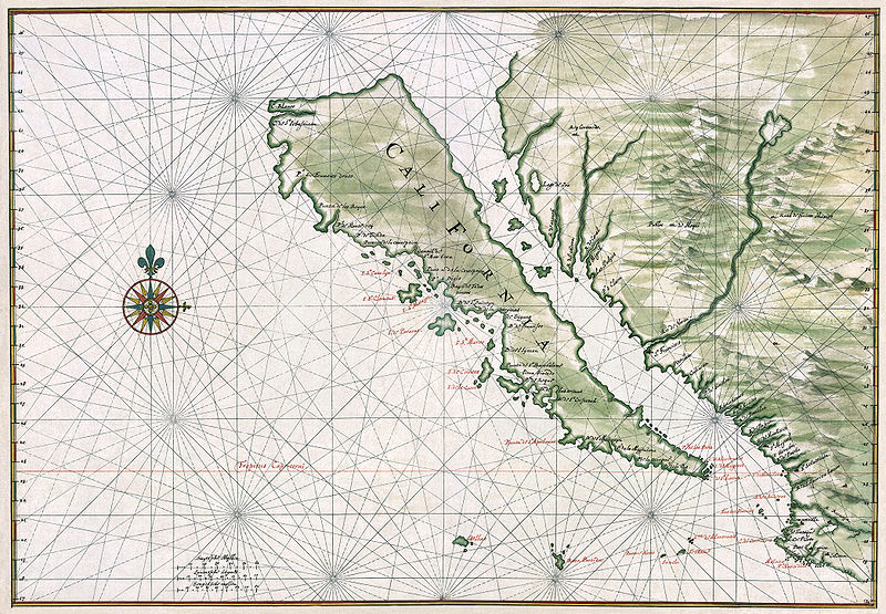
PPS [UPDATE 11.20.2012] I just read another fascinating blog on the subject of Sandy Island and discovered that the island appears on an old map also:
A librarian in Auckland, New Zealand located it on a chart of the Pacific Ocean, published in 1908 but first compiled in 1876. The island was sighted in that year by the British vessel Velocity.
--from Strange Maps, No Land Ho: Sandy Island and the Age of Un-Discovery

Thursday, April 22, 2010

Okefenokee Geography

I just realized that I haven't talked about the location of Okefenokee very much amidst all of the pictures.  Therefore I went looking for maps of the area and found a couple of good ones on Wikipedia.  First is the location guide at left so you can see exactly where the swamp is located.  I've known about it for years (if nothing else a geography program we used to have on the computer taught me the location), but many people said "Okefenokee where?" or "Okefenokee what?" when I told them where I was going for several days.  The swamp is located in southern Georgia, extending somewhat south of the state line into Florida.

Notice the two rivers--St. Marys and Suwanee that flow from the swamp.  Apparently there was much talk in the past of making a canal between the rivers to ease transportation between the Gulf of Mexico and the Atlantic without going around Florida.  I can tell you that the current going towards the Suwanee River is great when you get to the western side of the swamp.  Speaking of the western side of the swamp the next map concerns the canoe routes through the swamp.  The route that I've been showing y'all is the red trail which you can trace on the map starting from Kingfisher Landing.  I wish that I could have geotagged my pictures with the location--but when I upload some of them into Picasa Web Albums I'll do my best to tag some (like those in Maul Hammock) with their locations.


~Matt

Tuesday, April 20, 2010

Geographic Quiz

Last night I came home to find that the latest issue of National Geographic had arrived.  I enjoy reading the magazine, but before going through I start I always look at the address label.

There is always a short geography quiz printed at the top of the address label.  I enjoy testing my geographic knowledge against these questions.  Most of the time I can get a majority of them right, if not all five.  My nephew Chase is usually disgusted when I get them all right, wondering how I know such random things.  Once again this month I was able to get all five right, though some were very easy to guess or to know because of my history background.  I'll reproduce the questions below (originally from the National Geographic Bee) but not the answers until a few people venture guesses.

1. Bohemia and Moravia are two regions located in which formerly communist country that joined NATO in 1999?

2. From 1910 until World War II's end, the Korean Peninsula was controlled by which island country to its east?

3. Buddhism was introduced more than 2,200 years ago to which South Asian island country on the Gulf of Mannar?

4. In 1938, the Anschluss occurred when Germany annexed which other German-speaking country?

5. Which country's population does not include a large percentage of Hindus--Cambodia, India, or Nepal?

~Matt

Monday, December 14, 2009

Geographic Typo


This is a picture of my shower curtain. Can you notice the typographical error?

~Matt

-- Posted from my iPhone
(c) 2009 iWolff Ltd.

Location:Highland Ave,Fort Mitchell,United States

Friday, December 29, 2006

Geography is very important

Don't make a mistake like this German tourist.  He meant to visit his girlfriend in Sydney, Australia.  Instead he purchased a ticket on-line for Sidney, Montana (population 5,000).  The best part (and I'm assuming he speaks English, because his girlfriend lives in an English-speaking country) is that he didn't realize his mistake until after he landed in Portland, Oregon, flew to Bozeman, Montana, and was about to board a commuter plane for Sidney!  Compounding the problem was his packing--it was all for a four week trip Down Under in the middle of the Southern Hemisphere's summer.
 
This is why you should pay attention to geography.  I can understand how a typo could account for the initial mistake.  But I find it quite strange that he didn't notice the error until the point at which he noticed it.  I suppose he didn't know US geography very well and might have supposed that taking several flights through the US could be standard procedure before heading on to Australia.
 
"I did wonder but I didn't want to say anything," Gutt told the Bild newspaper. "I thought to myself, you can fly to Australia via the United States."
 
Still, this is sad.  I'd like to think that were I in that guy's shoes I would know when I'd arrived in Spain rather than Peru...
 
~Matt

--
"A room without books is as a body without a soul." -Cicero

Sunday, May 21, 2006

Montenegro

I love maps. Unless this is your first time here that can't be a surprise to you, ;-). Well I also enjoy tracking changes in maps. I own a massive National Geographic world map that hung on the wall of my bedroom at my parents house (until my dad and I built a floor-to-ceiling bookcase along that wall that is). I couldn't afford to go out and buy a new map each time something changed (and anyway the first was purchased at some sort of fair that we never went to again). I would instead write corrections on small pieces of paper and tack them to the map.

At the time I removed the map from the wall I know that I had several, Hong Kong's return to China in 1997, Maccau's return to China in 1999, Canada's new province Nunavut in 1999.

Other items I look for are Czechoslovakia (it broke up in 1993), Zaire (the name changed back to the Democratic Republic of the Congo in 1997), Timor-Leste's independence in 2002, South Vietnam, and now it appears Montenegro.

European maps were so simple before World War I. The west of the continent was basically the same as it is today, with the exception of the British Isles where the Irish gradually gained their independence. In the east though it was much simplier than today (not that I'm complaining exactly, I know all of the modern nations, and they're interesting) with the German Empire, Austro-Hungarian Empire, and the Russian Empire. Then came the imperial break-ups at the end of the "War to End All Wars" and maps have never been the same since.

Yugoslavia did simplify the Balkans for many years, but of course that was too good to last, and it eventually broke up following the demise of the Soviet Empire. However, the nation still persisted as the Federal Republic of Yugoslavia which consisted of former Socialist republics Montenegro and Serbia. In 2003 this nation changed its name to Serbia and Montenegro, a looser confederation. The time might have finally come for that to end. Montenegrans have apparently voted by a "slim margin" to sever their ties with Serbia and establish full independence. I'm not sure exactly what it will mean for the country, but on the map front I'm excited.

When you look back over the later part of the twentieth century there weren't that many significant changes to atlases. Yes, you did have the break-up of the Soviet Union, but there wasn't much else. When governments change (such as in Iraq following the downfall of Saddam Hussein) this fact doesn't register on the physical map of the nation. It isn't as easy to identify modern maps as it is to easily date something to a period of European colonization or before, during, or after WWII. The more changes there are, like Montenegro (and perhaps Kosovo in the future?) the more interesting things are for map followers.

~Matt

PS It is official. All new maps that you have are officially out of date. :-) I wonder how long until someone publishes an updated one actually... I'm also looking forward to the updated CIA World Factbook entry.