 purchased at some sort of fair that we never went to again). I would instead write corrections on small pieces of paper and tack them to the map.
At the time I removed the map from the wall I know that I had several, Hong Kong's return to China in 1997, Maccau's return to China in 1999, Canada's new province Nunavut in 1999.
Other items I look for are Czechoslovakia (it broke up in 1993), Zaire (the name changed back to the Democratic Republic of the Congo in 1997), Timor-Leste's independence in 2002, South Vietnam, and now it appears Montenegro.
European maps were so simple before World War I. The west of the continent was basically the same as it is today, with the exception of the British Isles where the Irish gradually gained their independence. In the east though it was much simplier than today (not that I'm complaining exactly, I know all of the modern nations, and they're interesting) with the German Empire, Austro-Hungarian Empire, and the Russian Empire. Then came the imperial break-ups at the end of the "War to End All Wars" and maps have never been the same since.
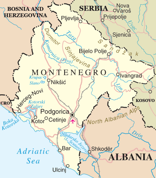
Yugoslavia did simplify the Balkans for many years, but of course that was too good to last, and it eventually broke up following the demise of the Soviet Empire. However, the nation still persisted as the Federal Republic of Yugoslavia which consisted of former Socialist republics Montenegro and Serbia. In 2003 this nation changed its name to Serbia and Montenegro, a looser confederation. The time might have finally come for that to end. Montenegrans have apparently voted by a "slim margin" to sever their ties with Serbia and establish full independence. I'm not sure exactly what it will mean for the country, but on the map front I'm excited.
When you look back over the later part of the twentieth century there weren't that many significant changes to atlases. Yes, you did have the break-up of the Soviet Union, but there wasn't much else. When governments change (such as in Iraq following the downfall of Saddam Hussein) this fact doesn't register on the physical map of the nation. It isn't as easy to identify modern maps as it is to easily date something to a period of European colonization or before, during, or after WWII. The more changes there are, like Montenegro (and perhaps Kosovo in the future?) the more interesting things are for map followers.
~Matt
PS It is official. All new maps that you have are officially out of date. :-) I wonder how long until someone publishes an updated one actually... I'm also looking forward to the updated CIA World Factbook entry.
No comments:
Post a Comment